Dubai intrigues the world with its luxurious artificial islands. These man-made paradises display the innovative strategies of modern engineering as it involves the collaboration of the most notable engineering firms for land reclamation. The most famous island, Palm Jumeirah, attracts thousands of vacationers a day, and with this increase in tourism, the ruler of the Unites Arab Emirates hopes to see an escalating economy. However, environmentalists worry that the development of these islands could pose serious threats to natural ecosystems as the process of creating new land involves taking sand and rock from one region and moving it to another. In addition to the environmental concerns, the potential erosion of the islands has the public wondering whether it is realistic for Dubai to continue building artificial islands.
“And God said, ‘Let the water under the sky be gathered to one place, and let dry ground appear.’ And it was so. God called the dry ground ‘land,’ and the gathered waters he called ‘seas.’ And God saw that it was good.” – New International Version, Gen. 1:9
Introduction
Whether our beliefs come from religious texts or scientific theories, humanity has always wondered how the natural world came into existence. Both science and religion suggest that a force stronger than human beings was created the land on earth. As intellectual beings, human beings analyze the natural world, seeking to understand how it works and developing technology to populate it better. We made clothing for warmth, the spear for hunting, and the wheel for transportation. We built bridges to cross rivers and ships to cross the oceans. Though humanity did not create the earth, or the land that comprises it, we built homes to inhabit it and farms to cultivate it. Now, as engineering technologies progress, human beings are building the land itself.
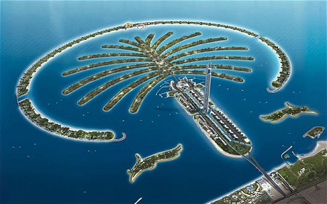
In the early 21st century, developers in Dubai began using land reclamation to construct the world’s largest cluster of artificial islands, the Palm Islands (Fig. 1). In science, land reclamation is the process of creating new land from sediment in oceans, riverbeds, or lakes. Traditionally, countries use this technique to add to the existing shoreline or develop small islands; for example, the Netherlands used land reclamation to increase the size of the country by 35 percent [1]. Other nations, such as the United States and the United Kingdom, use artificial islands for offshore oil drilling and military bases. In 1993, the United Arab Emirates (UAE) modernized the use of land reclamation by building a luxury hotel, the Burj Al Arab, on the artificial paradise island named Jumeirah [1]. The success of the Burj Al Arab was the initial catalyst that inspired the UAE to further develop their coastline.
Illumin
Figure 1: A rendered image of one of the Palm Islands.
Dubai’s collection of manufactured paradises consists of Jumeirah Island, the Palm Islands, and the World Islands. Scientists refer to these chains or clusters of small islands as archipelagoes. The Palm Islands are the most notable addition to Dubai’s coastline. Each of the three archipelagoes – Palm Jumeirah, Palm Jebel Ali, and Palm Deira – mimics the shape of a palm tree [2]. The World Islands consist of 300 islands that resemble the shape of an ovular world map and host private residences, shopping centers, and hotels. With access only by yacht or motorboat, these islands prove themselves as the ultimate luxury vacation spot [2].
Palm Jumeirah
The smallest of the palms, Palm Jumeirah, was completed in 2007 and is located approximately 23 kilometers southwest of the Dubai city center [3]. The island flaunts its 1,700 residential units with private docks, villas, and gardens. The trunk of the palm is composed of four thin islands that offer retail and hotels. There are 17 fronds that extent into the Persian sea, and a curved barrier reef with hotels surrounds the fronds. While this is the smallest of the archipelagoes, the ruler of the UAE, Sheikh Hamdan Bin Mohammed bin Rashid Al Maktoum, boasts that 800 football fields could sit on Palm Jumeirah alone [2].
Why Build More?
While overpopulation is not Sheikh Mohammed’s motivation for constructing the archipelagoes, he does believe that Dubai needs to increase its coastline to accommodate an influx of tourists to the region. Before the construction of the Palm Jumeirah, Dubai attracted about 5 million tourists each year. Sheikh Mohammed hopes the addition of 56,000 square kilometers of land, distributed along a 520-kilometer coast, will triple the number of visitors [2]. With a palm tree shaped island visible form space, surely Sheikh Mohammed has caught the world’s attention.
The UAE is depending on tourism as the nation’s next reliable source of income to replace the oil industry, which until recently has been responsible for much of the wealth in the country. In 2010, the New York Times published an article entitled “After Financial Crisis, Dubai Keeps Building, but Soberly,” which revealed Dubai’s true economic state [4]. Several economists across the globe estimate that Dubai will completely exhaust its oil supply by 2016. Sheikh Mohammed aims to use tourism to resolve this economic dilemma.
Construction
To manage the project, the UAE sought out the engineering firms responsible for the most notable example of land reclamation: the Belgian company Jan De Nul and the Dutch company Van Oord that collaborated on the land reclamation project that extended the Netherlands. Dubai World selected its private developer, Nahkeel Properties, to head all of the island projects. Additionally, Dubai World made CDM Smith responsible for the geotechnical design of the project [1].
Geography
The geography of Persian Gulf makes the region suitable for land reclamation. The gulf’s shallow coastal sea gets deeper very gradually as it reaches out into the open ocean, creating a reduced water depth around the shoreline [5]. The sea is on average only 10.5 meters deep. Furthermore, the Persian Gulf experiences a minimal number of sea storms when compared to gulfs in the Pacific and other regions in the western Atlantic Ocean [3].
Breakwater
Before the construction of the main palm, Van Oord developed the curved breakwater that would surround it. The breakwater is necessary to defend the main island from strong tides that could raise the sea level and flood the islands. The construction of the breakwater began in August 2001. It is four meters above sea level and 11.5 kilometers long. In August 2003, engineers determined that the enclosed nature of the breakwater was limiting the flow of water around the island, meaning that tides could not properly flush through the archipelago [6]. In order to prevent stagnant water, Van Oord put two 100-meter gaps in the breakwater that allow water to completely circulate through the sixteen narrow channels of the fronds every 13 days [1].
Procedure
The construction of the breakwater and of the main island used the same land reclamation technique. Engineers used large excavating machines, known as dredgers, to relocate sand from the deep sea to the area where the breakwater was to be constructed. Each dredger carried approximately 8,000 tons of sand and dumped the sand at a rate of 10 meters per second, fast enough to fill an Olympic sized pool in 4 minutes [6]. The dredgers ejected sand using a method called “rainbowing” [3]. In this technique, the dredger shoots sand at an angle and curves into the water in a parabolic shape that resembles a rainbow. The sand is then covered by a layer of water permeable geo-textile that prevents the grains of sand from eroding.
To keep the sand in place, the dredgers dropped heavy rubble and rocks onto the sand. The first layer is composed of one-ton rocks, and the top layer used rocks that weigh about six tons on average [1]. Altogether, the breakwaters used 5.5 million cubic meters of rock, which is half as much rock as the Egyptians used to build one of the pyramids in Giza [6].
Compression
After dredgers place the sand, machines called depth vibrators compact the sand. CDM Smith used depth vibrators to vibrate the sand in 12-meter layers so that it compressed into a more solid-like form using a technique called vibro-compaction. Using the depth vibrator significantly accelerates the process; while nature can take decades to perform vibro-compaction, depth vibrators reduce this time to about eight months [5].
Compression was necessary for two main reasons: first, the land had to be strong enough to withstand the construction of buildings, and second, the land had to be stable against the threat of earthquakes. Without proper compaction, the sand and rock could undergo liquefaction. Imagine a child building a sand castle out of dry sand. The sand has a tendency to roll down the sides of the structure if it is not well compacted. In the case of the islands, this would mean ocean water could more easily stir up sand on the side of the island and over time, which could erode the land back into the sea. Before construction, CDM Smith tested vibrocompaction on the building site to observe the behavior and performed large-scale tests in their lab. Ultimately, CDM Smith determined the technique was adequate for the construction of the Palm Islands [5].
Shape
One of the first popular ideas during the planning of Dubai’s artificial islands was to form the archipelago as one large shell, but Sheikh Mohammed eventually determined he wanted a more unique shape that would maximize the length of the coast. He eventually selected the palm tree shape because it allowed not one, but multiple coastlines along the island [2]. One of the most innovative aspects of the construction of the Palm Islands was the technique Vann Oord used that utilized a Global Positioning System (GPS) to properly shape the island. The GPS from a private satellite 676 kilometers above the earth’s surface ensured that the sand would be placed accurately. The use of GPS enabled the firm to form the complex curved shape of the breakwater and the slight curves of each palm frond. The construction workers on the dredgers had mobile receivers that functioned as reference points on earth, and the satellite sent coordinates of each point where dredgers would have to place sand [1].
Environmental Effects
Engineers could not implement a new landform into nature without first considering the effects of its construction on the pre-existing ecosystem. Although Dubai established a coast monitoring program in 1997, it seems as though they prioritized the development of the tourist attraction above the preservation of the natural environment. Researchers from the environmental science organization Mongabay found that the introduction of artificial islands changed the wave patterns along the coast. Some areas of the coast encounter waves of reduced force while others areas experience waves of increased force and frequency. Many scientists believe that the change in wave patterns is responsible for Dubai’s eroding coastline [7].
In addition to changes in the motion of water, scientists have observed changes in the consistency of the water in the region. Years of construction stirred up sediment that polluted the water. Researchers for Mongabay stated that the naturally crystalline waters of the Persian coastline are now clouded with silt, which has reduced the amount of natural sunlight that can reach coral reefs and has significantly damaged marine habitats. For example, scientists have found oyster beds buried under at most two inches of sediment. Additionally, scientists expect to see a decrease in subterranean fields of sea grass in the region [7].
These negative impacts on the environment have stirred up commotion with many of the world’s environment protection organizations such as Mongabay, World Wildlife Fund, and Green Peace. In 2006, the World Wildlife Fund declared the “UAE’s human pressure on global ecosystems (its ecological footprint) to be the highest in the world” [7] [8] .
Looking Forward
With the development of artificial islands, engineers take on the role traditionally assigned to some higher power or scientific force. The natural erosion of the World Islands suggests that man’s desire to recreate the natural world is unrealistic and could be a sign of nature’s system of “checks and balances” that ensures human beings do not go too far when meddling with the natural environment.
In 2008, Nahkeel announced the plan to build the Universe Islands. This would be an archipelago in the shape of the Milky Way that surrounds the World Islands. While the proposed islands sound like a neat idea, some critics believe that the challenges with constructing the World Islands could diminish the public’s faith in Nahkeel’s abilities. Perhaps the disintegrating World Islands serve as a warning for Dubai to halt the development of artificial islands.
The Palm Islands have not only captured the engineer’s ability to improve the natural world but have also revealed the value that society assigns to technology over ecology.
Additional Resources
National Geographic has a view which provides an overview of Palm Jumeirah: http://channel.nationalgeographic.com/channel/man-made/videos/palm-islands/
HowStuffWorks composed a video that walks through the construction process of Palm Jumeirah: http://adventure.howstuffworks.com/dubai-palm.htm
References
-
- [1] S. Dowdey, “Why is the world’s largest artificial island in the shape of a palm tree?,”
- HowStuffWorks, InfoSpace LLC.
- [2] Government of Dubai, “Palm Islands,” Government of Dubai, Dubai, 2013.
- [3] I. A. R. A. Darmaki, “Globalisation and Urban Development: A Case Study of
- Dubai’s Jumeirah Palm Island Mega Project,” Ph.D. thesis, Dept., Eng., Southampton
- Univ., United Kingdom, 2008.
- [4] L. Alderman, “After Crisis, Dubai Keeps Building, but Soberly,” New York Times,
- 29 September 2010.
- [5] CDM Smith Inc., “Palm Islands, Dubai – Compression of the Soil,” CDM Smith,
- [Online]. Available: http://cdmsmith.com/en-EU/ Solutions/Facilities/Palm-Island-
- Dubai.aspx. [Accessed 22 June 2014].
- [6] H. Jamal, “Palm Island Dubai – Palm Tree Island Mega Structure,” EnggPedia.com,
- [Online]. Available: http:// www.enggpedia.com/civil-engineering-
- encyclopedia/megastructures/palm-islands-dubai. [Accessed 19 June 2014].
- [7] “The Impact of the Palm Islands,” Google Sites, [Online]. Available:
- https://sites.google.com/site/palmislandsimpact/ environmental-impacts. [Accessed 19
- June 2014].
- [8] C. Bates, “Is it the end of the world?,” Daily Mail, 2 February 2010.