
Abstract
The Global Positioning System (GPS) evolved from the limitations of Transit satellites. GPS uses satellite data for trilateration to determine our location. The signals emitted from satellites are very weak, and this makes receivers susceptible to GPS spoofing: tricking the receiver into believing it’s somewhere it isn’t. Alternatives are being developed to eliminate GPS limitations. One alternative is called quantum accelerometers. Quantum accelerometers don’t rely on external signals and are remarkably accurate at determining an object’s position by measuring the acceleration of waves.
Keywords: Global Positioning System, GPS, Satellite Navigation, Trilateration
In 1957, the Soviet Union launched Sputnik, the first man-made satellite, into space. This shocked the world because many believed the US would be the first to launch a satellite. This would be the beginning of space exploration and implied a technological gap that made the US assume the Soviets must have other technology that had yet to be revealed. Sputnik’s launch raised Cold War tensions and intensified the arms race [1]. President Dwight Eisenhower tried to downplay the fear invoked by Sputnik. Still, he poured funding and resources into the space program that would become the National Aeronautics and Space Administration (NASA) [1]. The goal was to not just catch up to the Soviets but to surpass them.
Physicists and aerospace engineers realized they could track Sputnik by measuring its radio waves using a physical property called the Doppler shift: the apparent change in wave frequency [2]. This realization propelled the Navy to sponsor the Johns Hopkins Applied Physics Laboratory to develop satellites collectively called Transit in 1960 [3]. The Navy noticed a strategic advantage in satellite-based navigation. At the time, they couldn’t track their submarines unless they were close to the surface for long periods of time, putting them in danger of enemies trying to locate them [2]. Locating an object by measuring its radio waves would be an immense improvement over any other navigation system.
Although Transit was successful, it didn’t completely replace the US military’s abundant navigation systems. The Department of Defense (DoD) had 60 positioning and navigation systems across all its branches, many of which were incompatible with one another [4, 2]. Transit was used in conjunction with other systems, as it didn’t fulfill everything the DoD needed for its navigation. Transit could only track an object up to 200 meters and measure longitude and latitude, not altitude, making it difficult to track aircraft [2]. The impetus behind every invention is fulfilling an identified need that no one else could.
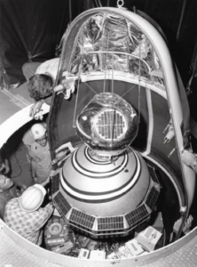
Figure 1. Transit satellite being prepared for launch.
.png)
NASA began unmanned space exploration with Project Gemini. This project aimed to test mission procedures in Earth’s orbit that could later be used in lunar missions. Gemini I was launched in 1964 and tested the structural integrity of the spacecraft [5]. Gemini III was launched in 1965 to test spacecraft maneuverability and would be the first crewed spacecraft. By 1966, the final Gemini spacecraft was launched, and its mission was to conduct three Extravehicular Activity (EVA) operations and demonstrate automatic reentry [5]. Automatic reentry is when a spacecraft enters the Earth’s atmosphere at a precise angle and speed to ensure a safe landing. The Gemini Project bridged the gap between the preceding Mercury program and the large-scale Apollo moon missions.
In 1973, the Vietnam War was ending, and the US was recovering from severe economic losses. US Airforce Colonel Bradford Parkinson oversaw a project called 621-B [6]. This project was a new satellite-based navigation system meant to improve upon Transit’s limitations. Parkinson quickly assembled a team of skilled engineers, including Hugo Fruehauf, Richard Schwartz, and James Spilker, and they rapidly formulated the project’s initial designs [7]. The team pitched the concept to the DoD, and it was quickly turned down [7]. It’s unclear why the DoD initially rejected the idea, but the economic hit from the Vietnam War was likely one of many reasons. Over the course of three days, the team would radically modify the design of 621-B. Schwartz and Fruehauf knew many obstacles were in place that could prevent the project from coming to fruition. They began designing an atomic clock capable of withstanding a rocket launch and space radiation [7]. Transit satellites weren’t equipped with atomic clocks, so this was a significant improvement.
For three months, Parkinson would travel to the Pentagon from Los Angeles to try and persuade the DoD to fund a full-scale demonstration of the new design [4]. Parkinson’s persistence proved to be worthwhile. By the end of the year, the DoD relented and provided funding for the project [4]. In 1978, the new navigation system was designed, four test satellites were launched in nine months, and it met every capability Parkinson had claimed for years [4]. With only four initial satellites, Parkinson proved this new system was extremely precise and had significantly fewer range restrictions compared to Transit. Altitude measurements were now possible, and this solved the Navy’s unreliable submarine tracking. This new navigation system was called Navstar Global Positioning System, which we now call The Global Positioning System (GPS).
GPS is universally used today because the team never meant for the project to be exclusively used by the DoD. Parkinson emphasized this in his initial meetings with Congress: GPS should be available to anyone who wishes to use it [7]. It’s impossible to say what navigation would be like if GPS was made purely for the military. Furthermore, the cost of a GPS receiver in 1970 was around a quarter of a million dollars, compared to only two dollars now [4]. GPS has transformed from a high-end commodity in the 70s to an essential feature in our wireless devices today.
How GPS Works
To understand how GPS works, we will analyze it as a three-segment system. The first segment, space, consists of 24 GPS satellites arranged in six orbital planes. Each satellite completes an orbit every 12 hours, which allows four satellites to be in view 24 hours per day [8]. Then, the control segment sends and receives signals from the satellites to keep track of their location and relay this data to a master control station [8]. Lastly, there is the user segment, GPS receivers. GPS receivers vary considerably depending on their use. However, every GPS receiver has an antenna calibrated to receive a signal from a GPS satellite, a receiver-processor unit that converts the signal into usable data, and a display unit that displays the positioning information [8]. All three segments send or receive signals through radio waves because they have measurable properties that allow distance and time to be calculated.
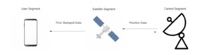
Figure 2. Signals with data being transmitted between segments.
Let’s say I’m driving from Los Angeles to Portland, Oregon, and I’m completely lost with only a map available for navigation. My only information is that I’m 300 miles from Los Angeles. This information alone isn’t helpful because I don’t know which direction I’ve gone. I draw a circle on the map with a 300-mile radius around Los Angeles. I spot someone hiking, and I ask them if they know where we are. They say they don’t, but they live in Fort Jones, California, and they traveled 350 miles to get here. Still not great information on its own, but I draw a second circle on my map with a 350-mile radius around Fort Jones. I can now see that these two circles intersect, and my location must be within this intersection. A family on a camping trip notices I’m lost and says they don’t have cell service, but they drove 235 miles from Santa Barbara. I draw a third circle around Santa Barbara with a 235-mile radius, and my potential position becomes significantly more accurate. There is only one point where all three circles will intersect at the same location. I can now see on my map that I must be in Modesto, California.

Figure 3. Determining a position using intersecting circles.
Determining a position by observing where circles intersect is known as trilateration. This is how GPS receivers determine our location based on the data they receive from satellites [9]. Our cell phones have various antennas. Some common antennas include Wi-Fi, Bluetooth, cellular service, and GPS. A GPS antenna listens for a GPS satellite’s signal [10]. Each satellite’s signal has timestamped data so the receiver can calculate how long it took to receive the signal, and these signals move at the speed of light [11].
C=3 x 10⁸ ms
The speed of light is the velocity at which the signal is moving. With the timestamped data from the receiver and the velocity of the signal, the distance between the receiver and satellite can be calculated using the following:
distance = velocity x time
Using this calculated distance, the receiver will draw lines radially away from the receiver [9]. These radii go off in all directions and create circles. Your location can then be determined by applying the concept of trilateration.
Let’s now upgrade our circles to spheres. GPS is meant to improve upon Transit’s 2-dimensional limitation. But trilateration in 3 dimensions is a little trickier. We need to account for a new dimension. However, these spheres will intersect at one point, making determining a location easier. Based on these two intersecting spheres, the receiver will know that we are somewhere in this 2-D intersecting space, as shown in Figure 4. Using the 2-D example, having only one sphere to determine our location becomes even less helpful. If we are 30 miles from satellite A, we only know we are somewhere on the surface of an imaginary sphere. If we add a second sphere 25 miles from satellite B, we create a perfect circle where the two spheres intersect [9].
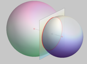
Figure 4. Intersection of two spheres creates a perfect circle.
https://www.grad.hr/geomteh3d/prodori/prodor_sf_eng.html
Now, let’s add one more satellite and consider Earth a fourth sphere. The third sphere intersects the perfect circle at two points. However, our fourth sphere, Earth, allows the receiver to determine a location because only one of the two points on the perfect circle would appear on Earth’s surface [9]. This is because each sphere would intersect with Earth, so it wouldn’t make sense for our location to be somewhere in space; the receiver eliminates one intersecting point as a possibility. GPS receivers aren’t limited to the number of satellites from which they can receive signals. However, GPS receivers want to locate at least four satellites for the most precise measurements. This is why 24 GPS satellites are in orbit; at minimum, four satellites are in sight of a receiver at any given moment. The more satellites send a signal to a receiver, the more accurately the receiver can calculate your location.
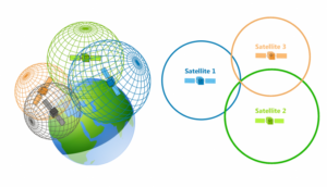
Figure 5. 3-D trilateration.
https://en.wikipedia.org/wiki/True-range_multilateration#/media/File:3D_Trilateration.jpg
Time is an important variable for a receiver when determining a location. But time is tricky. We are dealing with satellites and receivers very far from each other. Being off by even a few nanoseconds makes 3-D trilateration much more difficult. Each GPS satellite is equipped with a clock that has universally constant properties [2]. This means that they aren’t bound by Earth’s properties, can be launched into space, and remain extraordinarily accurate [2]. These are known as atomic clocks: synchronized clocks that GPS satellites must have to make accurate time calculations [8, 9]. There’s a problem, though. Atomic clocks cost between $50,000 to $100,000, making them uneconomical for everyday devices [9].
Nonetheless, receivers can compensate for their lack of atomic clocks. A receiver will compare its own time with that of the satellites and gauge its own inaccuracy [9]. The receiver recognizes there is only one possible value for the current time, the receiver then resets itself to match the time value of the satellites and gains the accuracy of atomic clocks for free [9]. This makes the calculation for the distance between the receiver and satellite accurate. Still, this doesn’t mean calculations with atomic clocks aren’t prone to errors. Although atomic clocks are exceedingly accurate, they can still have tiny, unavoidable errors. Being off by a few nanoseconds causes meters of error in position [11]. These errors are inconsequential for everyday use, but they could be an issue for a heavily reliant GPS.
Limitations
The signals that are transmitted to a GPS receiver are considerably weak. GPS signals must travel more than 12,000 miles between satellites and receivers [12]. Someone with malicious intent could easily send a slightly stronger signal from a software-defined radio to cause the receiver to believe it is somewhere, or somewhen, it isn’t [12]. For example, a spoofing device could mislead a vehicle transporting merchandise to a secluded location and steal their cargo. Spoofing devices are inexpensive and portable, making any GPS-reliant system highly susceptible to cyberattacks. Other countries like Russia and China have backup systems that users can switch to, but these are much more difficult to override [12]. We are dependent on an eminently vulnerable system.
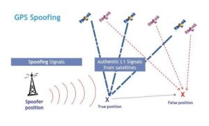
Figure 7. GPS spoofing.
Hla Oo’s Blog: GPS “Spoofing” Could Be Behind US Navy Collisions (hlaoo1980.blogspot.com)
One might presume that adding more satellites to space would strengthen GPS signals, lower the chances of timing errors, and eliminate spoofing. After all, the more satellites a receiver can see, the more precise the measurements will be. However, more satellites in orbit increase the odds of collisions. This could lead to something called Kessler Syndrome, a feedback loop of destruction that could make Earth’s orbit a no-fly zone [13]. This has been a recent concern with SpaceX launching their satellites for Starlink. Launching satellites also brings more aluminum into the upper atmosphere, which could damage the ozone layer [13]. This makes us more susceptible to skin cancer since the ozone layer protects us from ultraviolet radiation. Adding more satellites isn’t a sufficient solution to GPS limitations. The harms far outweigh the potential benefits.
The Future
A photonic company, M Squared, has been developing a quantum accelerometer that would remove the need for GPS satellites and receivers [14]. This device would be self-contained and measure the properties of supercooled atoms. At extremely low temperatures, atoms exhibit quantum behavior that demonstrates properties of both waves and particles, and quantum mechanics can then be used to describe how they move [14]. These waves and particles will reflect off objects, and this reflection can be measured by sensors. The receiving sensor compares the incident wave frequency with the reflected wave frequency. This allows the quantum accelerometer to determine what direction, and how fast an object moves. Powerful lasers make the atoms cold enough for these measurements [14]. This process resembles how the US military used the Doppler Shift to track the Sputnik satellite.
Unlike GPS, quantum accelerometers don’t rely on external systems to produce a measurable signal. There isn’t a satellite-receiver component where one produces a signal and the other receives it. A quantum accelerometer both produces and receives the signal through sensors [14]. Controlling the atoms in a self-contained environment makes extreme precision possible. During testing, the measurements done by quantum accelerometers were shown to be 50 times more reliable than classical sensors [15]. Currently, this system is far too bulky to be installed on anything other than large ships and vehicles. But quantum accelerometers are still in the development and testing phases, so they aren’t currently being used. However, this technological achievement opens possibilities for compact variations in the future. If made more accessible, quantum accelerometers could become the new universal navigation system.
Further Reading:
https://www.timeanddate.com/time/how-do-atomic-clocks-work.html
Multimedia:
https://www.youtube.com/watch?v=70cDSUI4XKE
https://www.sciencefriday.com/segments/how-gps-found-its-way/
https://www.youtube.com/watch?v=FWCN_uI5ygY
References
[1] Office of The Historian, “Milestones: 1953–1960 – Office of the Historian,” State.gov, 2019. https://history.state.gov/milestones/1953-1960/sputnik
[2] P. E. Ceruzzi, GPS. Cambridge, Massachusetts: The MIT Press, 2018.
[3] R. Danchik, “THE NAVY NAVIGATION SATELLITE SYSTEM (TRANSIT).” Available: https://secwww.jhuapl.edu/techdigest/Content/techdigest/pdf/V05-N04/05-04-Danchik.pdf
[4] M. Cooper, “GPS: The Roots of its Making and History,” ITNOW, vol. 61, no. 2, pp. 20–21, 2019, doi: https://doi.org/10.1093/itnow/bwz037/.
[5] NASA, “Project Gemini,” NASA, https://www.nasa.gov/gemini/
(accessed Dec. 11, 2023).
[6] AEROSPACE, “Brief History of GPS | The Aerospace Corporation,” Aerospace Corporation, Feb. 02, 2021. https://aerospace.org/article/brief-history-gps
[7] J. Loughran, “Interview: The creators of GPS,” eandt.theiet.org, Feb. 15, 2019. https://eandt.theiet.org/content/articles/2019/02/interview-the-creators-of-gps/ [accessed Sep. 02, 2023].
[8] S. Vatansever and I. Butun, “A broad overview of GPS fundamentals: Now and future,” in 2017 IEEE 7th Annual Computing and Communication Workshop and Conference (CCWC), 2017, pp. 17–6. doi: 10.1109/CCWC.2017.7868373.
[9] M. Brain and T. Harris, “How GPS receivers work,” HowStuffWorks, Mar. 2023, [Online]. Available: https://electronics.howstuffworks.com/gadgets/travel/gps.htm.
[10] C. Woodford, “How does GPS satellite navigation work?” Explain that Stuff, Apr. 2007. https://www.explainthatstuff.com/howgpsworks.html
[11] S. C. Bhardwaj, S. Shekhar, A. Vidyarthi, and R. Prakash, “Satellite Navigation and Sources of Errors in Positioning: A Review,” IEEE Xplore, Aug. 01, 2020. https://ieeexplore.ieee.org/abstract/document/9212941 [accessed Sep. 04, 2023].
[12] P. Tullis, “GPS is easy to hack, and the U.S. has no backup,” Scientific American, Dec. 2019, doi: 10.1038/scientificamerican1219-38.
[13] N. Scharping, “The Future of Satellites Lies in the Constellations,” Discover Magazine. https://www.discovermagazine.com/the-sciences/the-future-of-satellites-lies-in-the-constellations [accessed Sep. 02, 2023].
[14] J. Loughran, “Quantum ‘compass’ enables global navigation without satellites and GPS,” E&T Magazine, Nov. 13, 2018. https://eandt.theiet.org/content/articles/2018/11/quantum-compass-enables-global-navigation-without-satellites-and-gps/.
[15] L. Papadopoulos, “Researchers invent first ever 3D quantum accelerometer for use in ships and submarines,” interestingengineering.com, Nov. 05, 2022. https://interestingengineering.com/innovation/first-ever-3d-quantum-accelerometer