peeterv // Getty Images
Abstract
Traffic light sensors have an important role in guiding motor vehicles and pedestrians safely to their destinations while also clearing traffic congestion as efficiently as possible. As roadway vehicles are the primary source of transportation in nearly every country, many engineers and scientists have come together to create various sensors to help alleviate traffic congestion and identify its underlying causes. This article will dive into previous, current, and possible future solutions the Department of Transportation has implemented to alleviate traffic congestion. Brute-force road expansion was initially implemented to relieve congestion but was soon dropped after realizing that it was not a cost-effective solution. In the future, we may look forward to seeing traffic lights that are synchronized across entire metropolitan areas with some form of machine learning to find the most efficient light patterns.
Introduction
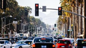
Have you ever been stuck in horrible traffic, with back-to-back red lights, especially when you really need to get somewhere? There might also be times when you are driving and never hit a single red light on your way home. Have those always been just strokes of good luck? Maybe, but the reason for your fortune can most likely be attributed to many years of data collection done by analysts in the electronics and transportation industry. Unfortunately, being stuck in stand-still traffic is mostly attributed to high-density urban populations. However, it has been reduced significantly due to the Department of Transportation’s (DOT) implemented solutions.
In the 1990’s, the primary solution utilized was to invest in the Intelligent Transportation Systems (ITS) infrastructure and install vehicle sensors to better alleviate traffic conditions at intersections. A second solution adopted in the early 2000s was to increase the capacity of our transportation systems to keep up with urban sprawl.
The Existence of Regular Traffic
Due to the rapid swelling in the population of major cities in the United States, it has become increasingly hard to manage traffic flow, especially during busier hours of the day [2,5]. In a study, the DOT estimated that the country loses “$200 billion a year due to freight bottlenecks and delayed deliveries” and “consumers lose 3.7 billion hours and 2.3 billion gallons of fuel sitting in traffic jams” in 2006 [5]. Below is data from the last 40 years of excess fuel burnt due to congestion, resulting from the increase in urban sprawl.
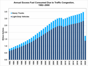
Figure 1. Amount of fuel being burnt by all vehicles while waiting in traffic [14]
In 2002, the DOT also stated that it would have to increase the capacity of its transportation systems by 25 percent every 10 years – or about 4,200 lane miles of new roadway every year, but has found it hard to do so due to the cost of such construction projects [5]. Anyone could tell that this would no longer be a viable option as the demand for transportation capacity increased faster than these transportation systems could physically expand. The DOT then decided to shift towards funding the already existing ITS program [5].
Brief History of the ITS
The ITS program was created in the early 1990’s in order to enhance public safety, reduce congestion, improve access to transit information, generate cost savings for motor carriers and government agencies, and reduce detrimental environmental impacts [5]. It was meant to handle the increase in travel demand and initially focused on road expansion but then started dealing with more intelligent systems compiled of more data [5]. These systems would mostly be independent vehicle sensors installed at intersections and small roads. The DOT then restructured the ITS along with researchers from New Mexico State University to create a team with a new mission: to gather more data in order to gain a better understanding of the problem. This new team, the Vehicle Detector Clearinghouse (VDC), was established in 1996 [12]. They sent out requests to the private sector to get a gauge of what software and hardware technologies existed to help them get this data and used a mere Excel sheet to compile and organize all of their findings from 86 different companies [6].
With this information, they were able to start purchasing and standardizing a variety of technical sensors to apply to the roads. Further, new legislation in 1998 created the Transportation Equity Act which no longer allowed the ITS to be treated as a special niche research program but, rather, as a qualified mainstream transportation division that is eligible to use the $286.4 billion bill allocated for transportation purposes [5]. The VDC instantly saw an improvement in traffic conditions and lessened the need to create wider roads, arguing now that more funding towards the ITS would reduce the cost of mitigating recurring congestion by approximately 35 percent nationwide [5].
As a result of many organizations’ research, including the VDC’s, the Department has since committed much funding to the research and installation of many different kinds of sensors.
Modern Standardized Solutions
Overall, there are two types of vehicle detection methods: in-roadway and over-roadway sensors [7]. A sensor is considered “in-roadway” if it is installed on, embedded in, or installed below the road surface [8]. An above-roadway sensor is one that does not require the installation of the sensor directly onto, into, or below the road surface and is mounted over the center of the roadway or to the side of the roadway [10].
Further, these sensors could be subcategorized into data-gathering sensors and direct stop-light sensors. Data gathering sensors’ sole purpose is to gather information on how traffic flows in a region. This includes traffic intensity on specific roads and drivers’ brake distances, turn signal times, and reaction times. Direct stop light sensors are sensors that directly impact the stop signal of the adjacent intersection.
Below are the descriptions of each type of sensor, along with their strengths and weaknesses.
In-Roadway Sensors
Inductive Loop Detectors
In this system, a thick wire is looped under the pavement and charged with various frequencies depending on the application. The loop “functions as an inductive element” and, when vehicles pass over it, “the inductance of the loop is decreased” [8]. When it reads that the inductance has decreased, it sends a request to the light, signaling that a car is waiting at the limit line.
The figure below depicts one orientation of an inductive loop sensor. The way that this system operates is a bit more complicated compared to the rest of the sensors, but also the most reliable and most used sensor by far [1,8].
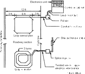
Figure 2. Schematic of inductive loop sensor [8]
This type of sensor has many advantages, being praised as the most “mature” by the DOT [8]. It can pick up a variety of vehicles, even heavier semi-trucks. It is multifunctional, meaning it can be used at intersections to check if a vehicle is waiting or even applied on highways to measure the speed, headway, and volume of traveling vehicles [7,8]. Therefore, this sensor can classify as both a data-gathering and direct light sensor.
There are also some disadvantages, especially for cyclists and motorcyclists as their vehicles usually do not consist of enough dense metals to trigger this sensor. This means they often need to wait for a larger vehicle to trigger the sensor or wait for a few cycles to run the red – which is legal in many states [8,13]. The installation of this sensor also requires extensive road closure, which is sure to disrupt the flow of surrounding traffic [8]. Lastly, the surface above the loop wears away quickly due to the cutting of the old pavement in order to install this sensor[8].
Pneumatic Road Tubes
Pneumatic road tubes are typically long,black tubes filled with air and laid across the road perpendicular to oncoming traffic. The tubes send bursts of air that a box at the other side of the road counts. They are typically meant to only count the number of vehicles that cross but can potentially take in other pieces of data like how fast traffic is going, how many axles the vehicles have, stop sign delay, and more. [3,8]. Below is a picture of possible orientations for these tubes as well as a box that would rest at the end of the tubes, reading the pressure.
Figure 3. Pneumatic road tube orientation and the pressure reader for the tubes [8]
The data from this tool is not fed directly into traffic lights but, instead, sent to and compiled by analysis software in order to make changes to traffic light timers if needed. This makes this sensor a solely data-gathering one.
These tubes have the advantages of low cost, low maintenance, low power usage, and low installation time [8]. It can be difficult for analysts when the tubes are slit as a result of vandalism, when trucks wear the tubes down, and when the volume of 3+ axle vehicles is too high [8].
Magnetic Sensors
Magnetic sensors are trained to remember the Earth’s gravitational field at the location of installation and send a signal when they detect a change in the electromagnetic force above it. The first figure below shows the general concept behind the origin of this type of sensor and its functionality is very similar to that of the inductive loop sensor. In other words, it shows how a car slightly disrupts the Earth’s electromagnetic field around it. The next two depict two variants of this type of sensor.
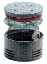
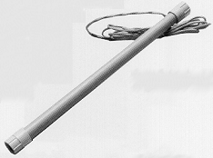
Figure 4. Magnetic sensors and their resulting disturbance to the Earth’s electromagnetic field [9]
These sensors are advantageous because they are less susceptible to traffic as they barely take up any space in the pavement, also meaning that they are easier and take less time to install than inductive loop sensors[9]. Their disadvantages include not being able to detect stopped vehicles and having small detection zones [9]. This classifies this sensor as a data-gathering one.
Above-Roadway Sensors
Engineers must consider the placement of above-ground sensors to ensure good visibility even in the face of fog, rain, or other weather; excess foliage; blind curves, or hills [2].
Video Image Processors
These video cameras, or Video Image Processors (VIP), are usually not installed alone and use software to identify the same vehicle from different angles [10]. This helps analysts see when people tend to brake, use turn signals, run red lights, and how close drivers are to each other. The figure below depicts a common VIP that you would find posted high up at many intersections.
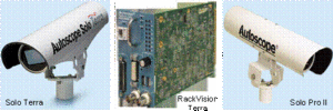
Figure 5. Video Image Processors [10]
The advantages are plenty when it comes to video cameras. So much extra information is compiled like the ones listed above and newer versions of vehicle detection software are becoming constantly available [10]. These are also much easier and cheaper to purchase and install than other sensors due to the simplicity of the hardware [7,10].
They are disadvantageous when weather conditions like rain, fog, or snow make it hard for the information to be visible [7,10]. They also require frequent cleaning of the lenses since they are purely visual sensors [7,10].
These sensors are usually used in tandem with other sensors in order to increase the confidence factor of a resting car. Since VIP’s are also used to gather miscellaneous information, they classify as both data-gathering and direct light sensors.
Microwave Radar
Using the technology developed to detect moving aircrafts, traffic analysts and ITS software can detect motor vehicles traveling on a road with microwave radar [10]. These are typically found at the top of stop lights or are sometimes posted on tall poles in between lights.
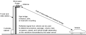
Figure 6. Schematic of microwave radar detection of cars [10]
They are great for bad climate conditions, direct measurements of speed, and gathering data on multiple lanes of traffic [7,10]. Similar to magnetic sensors, these radar systems cannot detect still vehicles unless paired with auxiliary sensors [10]. Due to their inability to detect still vehicles, these sensors are solely used for data-gathering.
Infrared Sensors
A passive infrared sensor depicted in both Figures 32 and 33 uses the change in emitted energy to detect a vehicle [10]. The active infrared sensor depicted in Figure 29 consists of two parts, one infrared laser that shoots a beam and two wide infrared sensors that can pick up the signals [10].
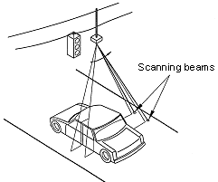

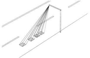
Figure 7. Schematic of infrared detection of cars [10]
The obvious advantages of over-roadway sensors are that they do not require the closure of the road and would never have to drill into the pavement. If these sensors are mounted at the side of the road, it is possible for them to gather information on multiple lanes [7,10]. Active infrared lasers also have the ability to measure vehicles’ movement speed [7,10].
These sensors are also disadvantageous when there is smoke, snow, fog, or dust in the way of these sensors and could result in corrupted readings [7,10]. There is also the possibility that a glimmer of reflected sunlight could corrupt the sensors’ readings as well [10].
Because of the versatility of infrared applications, these sensors are considered both data-gathering and direct light sensors.
Innovative Solutions
Although these solutions have alleviated much pressure from larger roads and overall traffic, many governments and organizations are ambitiously trying to outdo the technology we have incorporated today. For example, SCATS, the governmental traffic organization in Sydney, works on unifying multiple traffic lights in one area and sending live information from each light through a database in order to perfect the timing of other lights, making traffic go by smoother in real-time [4].
“Smart traffic signal system” cleantech.com [4]
Surtrec is a private software that uses “artificial intelligence” or, more likely, machine learning to achieve its goal in a similar way [4]. They boast that this system “decreased travel time by 25%” and that it “[led] to a 20% reduction in carbon emissions” [4]. This software works by constantly being fed raw data from every sensor in a region and learning, on its own, how the city “moves” throughout the days, weeks, and months.Their system is unique in its ability to automatically sense traffic and real-time weather conditions in order to factor theminto its decision-making [4]. The company also imagines a more ideal world where every device, vehicle, and building is interconnected and constantly communicating locations and directions in order to achieve the best possible traffic scenarios.
Conclusion
As much as people hate traffic, they love their privacy. Further, the thought of some entity knowing your every move and intention seems dystopic. I’m not claiming that we should no longer make any improvements to our traffic network. Imagine if emissions and traffic congestion were 25-35% worse than they already are today. The Department of Transportation is doing a steady job at finding intuitive solutions and utilizing specific sensors over brute force in road expansion. Therefore, I would predict that adopting machine learning software similar to Surtrec would be the most beneficial to the future of traffic while facing little to no pushback from the population.
Contact Information
Name: Daniel Suh
Phone: (916) 945-4584
Email: dsuh8205@usc.edu
Suggested Multimedia
Trafdata. Title of Video: Traffic Signal Loop Detector Installation – Part 1. (January 15,
2010). Accessed: January 23, 2023. [Online Video]. Available: https://www.youtube.com/watch?v=KvzJn09DqaM
CityOfBloomingtonMN. Title of Video: How it works: Road Tube. (Jun 11, 2014).
Accessed: January 23, 2023. [Online Video]. Available: https://www.youtube.com/watch?v=Y4RUnJ0EiFk
MetroCount. Title of Video: How to Install Inductive Loops for Traffic Data | RoadPod VL | MetroCount. (Feb 5, 2017). Accessed: January 23, 2023. [Online Video]. Available: https://www.youtube.com/watch?v=Z_7eJwsMFHk
Suggested Readings
- Butterfly, “Traffic signals and intersections: An innovative approach,” FindLight Blog, 27-Jun-2021. [Online]. Available: https://www.findlight.net/blog/traffic-signals-and-intersections-an-innovative-approach/. [Accessed: 25-Jan-2023].
- Gibson, “A new look at sensors,” A New Look at Sensors | FHWA, Nov-2007. [Online]. Available: https://highways.dot.gov/public-roads/novdec-2007/new-look-sensors. [Accessed: 25-Jan-2023].
“Office of Highway Policy Information – Policy: Federal Highway Administration,”
Office of Highway Policy Information – Policy | Federal Highway Administration, November 7, 2014. [Online]. Available: https://www.fhwa.dot.gov/policyinformation/pubs/vdstits2007/01.cfm. [Accessed: January 23, 2023].
Search Term List
Civil Engineering, Electrical Engineering, Transportation, Embedded Systems, Artificial Intelligence
References
[1] “How traffic lights sensors work: Automate Systems,” Auto Mate Systems Ltd.,
Apr 15, 2021. [Online]. Available:
https://www.automatesystems.co.uk/how-traffic-light-sensors-work/. [Accessed: January 23, 2023].
[2] D. Gibson, “A new look at sensors,” A New Look at Sensors | FHWA, 2007. [Online].
Available: https://highways.dot.gov/public-roads/novdec-2007/new-look-sensors.
[Accessed: January 23, 2023].
[3] J. T. Westbrook, “Here’s what those weird black tubes in the road are for,” Jalopnik,
April 4, 2018. [Online]. Available: https://jalopnik.com/heres-what-those-weird-black-tubes-in-the-road-are-for-1824997739. [Accessed: January 23, 2023].
[4] B. Butterfly, “Traffic signals and intersections: An innovative approach,” FindLight
Blog, June 27, 2021. [Online]. Available: https://www.findlight.net/blog/traffic-signals-and-intersections-an-innovative-approach/. [Accessed: January 23, 2023].
[5] “Office of Highway Policy Information – Policy: Federal Highway Administration,”
Office of Highway Policy Information – Policy | Federal Highway Administration, November 7, 2014. [Online]. Available: https://www.fhwa.dot.gov/policyinformation/pubs/vdstits2007/01.cfm. [Accessed: January 23, 2023].
[6] “Office of Highway Policy Information – Policy: Federal Highway Administration,”
Office of Highway Policy Information – Policy | Federal Highway Administration, November 7, 2014. [Online]. Available: https://www.fhwa.dot.gov/policyinformation/pubs/vdstits2007/02.cfm. [Accessed: January 23, 2023].
[7] “Office of Highway Policy Information – Policy: Federal Highway Administration,”
Office of Highway Policy Information – Policy | Federal Highway Administration, November 7, 2014. [Online]. Available: https://www.fhwa.dot.gov/policyinformation/pubs/vdstits2007/03.cfm. [Accessed: January 23, 2023].
[8] “Office of Highway Policy Information – Policy: Federal Highway Administration,”
Office of Highway Policy Information – Policy | Federal Highway Administration, November 7, 2014. [Online]. Available: https://www.fhwa.dot.gov/policyinformation/pubs/vdstits2007/04.cfm. [Accessed: January 23, 2023].
[9] “Office of Highway Policy Information – Policy: Federal Highway Administration,”
Office of Highway Policy Information – Policy | Federal Highway Administration, November 7, 2014. [Online]. Available: https://www.fhwa.dot.gov/policyinformation/pubs/vdstits2007/04pt2.cfm. [Accessed: January 23, 2023].
[10] “Office of Highway Policy Information – Policy: Federal Highway Administration,”
Office of Highway Policy Information – Policy | Federal Highway Administration, November 7, 2014. [Online]. Available: https://www.fhwa.dot.gov/policyinformation/pubs/vdstits2007/05.cfm. [Accessed: January 23, 2023].
[11] “Office of Highway Policy Information – Policy: Federal Highway Administration,”
Office of Highway Policy Information – Policy | Federal Highway Administration, November 7, 2014. [Online]. Available: https://www.fhwa.dot.gov/policyinformation/pubs/vdstits2007/05pt2.cfm. [Accessed: January 23, 2023].
[12] Vehicle Detector Clearinghouse (Southwest Technology Development Institute), “The
Vehicle Detector Clearinghouse (VDC) : A summary report,” ROSA P, 01-Jan-1970. [Online]. Available: https://rosap.ntl.bts.gov/view/dot/4098. [Accessed: 25-Jan-2023].
[13] P. Gusner, “Motorcycles can legally run red lights in these states,” Business Insider,
26-Nov-2016. [Online]. Available: https://www.businessinsider.com/motorcycles-can-legally-run-red-lights-in-these-states-2013-11. [Accessed: 25-Jan-2023].
[14] Vehicle Technologies Office, “FOTW #1204, Sept 20, 2021: Fuel Wasted due to U.S. traffic congestion in 2020 cut in half from 2019 to 2020,” Energy.gov, https://www.energy.gov/eere/vehicles/articles/fotw-1204-sept-20-2021-fuel-wasted-due-us-traffic-congestion-2020-cut-half [Accessed May 5, 2023].
Note: [5-11] are found on the same domain but require navigation in order to move to the next page. As each page is a different URL, they are individually cited in this article.