Adam Goetsch was a senior from Sammamish, Washington in the fall of 2005. He was majoring in Computer Science at the University of Southern California.
The Global Positioning System (GPS) is rapidly becoming an integral part of our everyday lives. The system, created by the United States Department of Defense in 1973, has gone through many changes since its introduction to the public in 1995. GPS uses the concept of trilateration to provide your location, but relies on Differential GPS and atomic clocks to vastly improve the accuracy. With such precision, GPS is being used in myriad applications including personal navigation and military missile guidance systems. And as this technology continues to decrease in price, GPS will likely be used in increasingly more exciting applications such as digital file security. First, though, the U.S Government must address the issue of privacy as it pertains to GPS.
Introduction
We’ve all been there: you are cruising down the street, desperately trying to peer out your window and read the street numbers. Did you make a wrong turn? Soon, you come to a realization that you have been dreading: you’re lost. In the past, this was a very common occurrence. But since the advent of the Global Positioning System (GPS), an increasing number of people are able to easily navigate to their desired destination. GPS technology allows users to pinpoint their exact location through a small GPS receiver. Today, GPS receivers are found in cars, boats, planes, laptop computers, tractors, and countless other applications.
In order to fully appreciate the importance of this technology, it is important to understand how GPS works, its current applications, potential problems associated with GPS, and expected future applications. First, however, one must understand the motivations behind the creation of GPS.
History
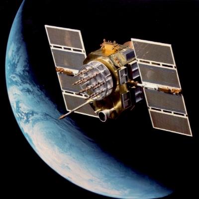
In 1973, the idea of a Global Positioning System, initially dubbed NAVSTAR, was developed by the United States Department of Defense. Originally, the technology was intended solely for military personnel and transportation units to obtain their location [1]. Five years later, in 1978, the first four GPS satellites were launched into space by the U.S. Department of Defense. GPS did not reach full operational capacity until July 17, 1995, because a minimum of 24 satellites are needed to provide full coverage.
Before the commercial release of GPS, the Department of Defense announced that two different GPS services would be developed: Standard Positioning Service (SPS) and Precise Positioning Service (PPS). SPS, eventually activated eight years later, was to be released to the public while PPS was to be reserved for use by the U.S military. The essential difference between SPS and PPS was that a deliberate random error was used in SPS to prevent civilians from obtaining exact coordinates through a technique called Selective Availability (SA) [2]. SA degraded the signal by roughly 100 meters by slightly altering the satellites’ clocks [3]. The DOD felt that this change was necessary to protect the security interests of the U.S. and its allies by denying the full capabilities of GPS to potential enemies.
President Bill Clinton ended the SA service on May 1, 2000. He explained that “worldwide transportation safety, scientific, and commercial interests could best be served by discontinuation of SA” [4]. Because they are still able to selectively deny GPS signals regionally in the case of threatened national security, the DOD felt that SA could be eliminated without making the U.S or its allies vulnerable. While SPS is still not as precise as PPS, the termination of SA increased its accuracy fivefold.
How It Works
To understand how GPS can display your location on your PDA, it is necessary to examine four key areas: the concept of trilateration, how distance is measured, atomic clocks, and how error is diminished through differential GPS.
Trilateration
Trilateration is the basic concept that drives GPS. Each of the 29 satellites in the GPS network circles the earth twice daily. The total of 29 (24 operational, 5 backups) was reached because, with this number, it was determined that at minimum four satellites are visible from any point on Earth [5]. The following discussion demonstrates the necessity of always having four satellites visible at any time.
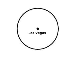
A single satellite essentially relays one critical piece of data: the distance between itself and the inquiring device. Let us call your distance from the satellite D. The circular area around that point represents everywhere on the surface of the earth a distance D from the satellite (Fig. 1).
Obviously, this alone is not very helpful. To better understand this concept, imagine telling someone that you are 150 miles from Las Vegas. All this means is that your location can be found at any point within a 150 mile radius from the center point of Las Vegas.
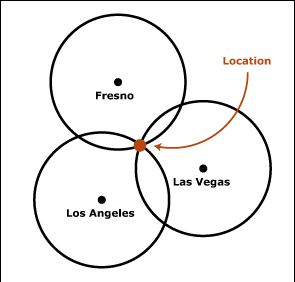
Choosing a second point and determining the distance from that city greatly narrows the possibilities. If you tell your friend that you are also 150 miles from Los Angeles, you can be one of the two places, where the circles overlap over each other (Fig. 2).
Giving your friend yet another distance from a new location will pinpoint your location. If you tell your friend that you are 100 miles from Fresno, the circle with a radius of 100 miles and center point of Fresno will intersect with one of the two intersection points created by the circles surrounding Las Vegas and Los Angeles. The intersection of the three circles is your location: Telescope Peak in the Death Valley National Park (Fig. 3).
If the Earth were either flat or a perfect sphere, perhaps this would be enough information. Our terrain, along with the fact that the inquiring device may not be on the surface of the Earth (e.g. in an airplane), requires that a fourth distance is given in order to obtain elevation. This distance is calculated in the same way as the other three distances. In order to imagine the addition of a fourth distance, we must envision the above figures as featuring spheres rather than circles. Adding a fourth sphere to the above example would then give the precise three-dimensional location: 11,049 feet above sea level at Telescope Peak in the Death Valley National Park (Fig. 4).
Measuring Distance
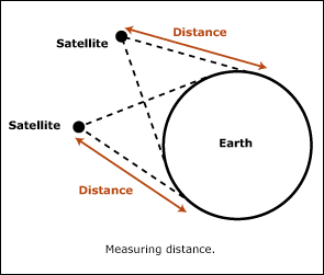
With the preceding discussion in mind, it is clear that the critical task of GPS is to determine an exact distance between a satellite and receiver. To understand how this is done, we need to look at the interaction between one satellite and one GPS receiver. The satellite constantly streams a “digital radio signal which includes its own position and the time” [1]. The receiver then decodes this information and subtracts its own time from the time sent by the satellite. From this, the receiver is able to compute the distance between the two by solving for x in the following equation:
186,000 miles/1 hour = x/calculated time(1)
From this, it is apparent that increasing the accuracy of the time difference will increase the accuracy of the distance.
The most accurate clock in the world is the atomic clock. Measuring to a billionth of a second, an atomic clock can give the most precise time, which is very useful with GPS. Atomic clocks keep time by using the regular oscillations (or vibrations) of atoms as a metronome [1]. In order to get the most precise value, both the satellites and GPS receivers would need to have atomic clocks. Atomic clocks, though, are quite expensive; they range from $50,000 to $100,000 [5]. Because of this, only the satellites are equipped with atomic clocks. This is a good compromise, as there are a small number of satellites compared to the large number of GPS receivers. Currently, receivers utilize simple quartz clocks similar to those found in a wristwatch [1]. Less accurate atomic clocks that are 1,000 times more accurate than quartz clocks have recently been developed. GPS receivers will likely employ the use of these clocks in the near future as they become less expensive [6]. The current configuration inevitably leads to error because the quartz clock is over 300,000 times less accurate than the atomic clock [7].
Differential GPS
Differential GPS (DGPS) is a technique used to increase the accuracy of a receiver’s location. DGPS was originally created to help overcome the error caused by Selective Availability (as discussed earlier) in the receiver’s measurement. Although SA has ended, DGPS is still used because its purpose of diminishing error is still useful. It works by using stationary GPS receivers at known locations all around the world. These GPS receivers continually calculate their own position based on information received by the satellites and then compare this position with their actual location. The difference between the two then allows these receivers to compute the error. This information is then passed along to DGPS enabled devices. Using this information, your GPS receiver (if able to accept the DGPS corrections) can adjust its own calculation based on the current error of the region to increase its accuracy. A GPS receiver receives data from the satellites as well as signal correction data from local GPS stations. GPS receivers that are able to accept DGPS corrections are most commonly found in planes, but they are slowly becoming more common as prices continue to drop.
Current Applications
GPS technology is currently being used by the military as well as transportation, science, and agriculture. Since a discussion about every use of GPS would be excessive, we will simply focus on a few. We will discuss personal navigation, which is currently the most common application. Next, we will look at how farmers are utilizing GPS to streamline production. This application will provide the framework to understand how GPS can be used in automation, which is becoming increasingly important. First, though, it is key to understand the application for which GPS was developed: military use.
Since GPS was designed by the United States Department of Defense, it is comes as no surprise that the predominant use of GPS is in the military. Along with having GPS receivers in many vehicles, the military has found that GPS can aid in aerial strikes. Missiles such as the Tomahawk cruise missile are equipped with a GPS receiver. If the precise location of the target is obtained, it can be loaded into the software [8]. Then the missile with the embedded GPS receiver is launched towards the target. The receiver continually calculates its distance from the target, which is then used by other software on the missile to adjust its trajectory mid-flight [8]. This results in increased precision and decreased collateral damage.
Because of the decreasing costs of GPS receivers, the general public is increasingly utilizing GPS technology. The most common application is personal navigation. Typically, the GPS receiver is installed in a vehicle or on a computer and the data is used by a software program to show the current location on a map. From there, the software can map to a destination, track progress, show current speed, and provide countless other useful functions [9]. Airplanes use GPS in a similar fashion.
Farmers have also found a creative use for this technology. By installing a computer and GPS receiver on a tractor, a field can be autonomously tilled, sprayed, harvested, or planted. When the tractor is first programmed, the GPS receiver continuously calculates and records its position. Once the operator of the tractor completes the desired route, the route is saved by the software [10]. Then on each subsequent trip, the GPS receiver on the now unmanned tractor calculates its position and sends it to the software, which then relays directions to the tractor.
Potential Problems
Of course, with the many benefits that it provides, GPS also has its share of problems. Given that GPS lends itself to myriad uses, some of those uses are bound to be problematic. Moreover, the lack of laws governing GPS use is likely to cause trouble. Lastly, the lifespan of GPS satellites is short enough to cause concern for the system’s future. Unfortunately, GPS can be used for immoral purposes (a debate about the morality of military applications is beyond the scope of this paper). GPS is being used by some to stalk unknowing victims. By simply hiding a GPS receiver on a vehicle, a stalker can record the vehicle’s whereabouts [11]. This is not only a problem because it is so simply performed, but also because legislation regarding questionable uses of GPS to invade others’ privacy has not kept pace with the developing technology.
At present, there are no laws governing the data received from GPS receivers. There are laws that protect one’s general privacy, but there is nothing that specifically addresses the GPS issue [12]. This will become an increasingly important issue as GPS receivers continue to decrease in price. It is becoming quite easy, as discussed in the previous section, to track people unknowingly, so legislation is needed to remedy this problem.
One other concern that has been raised recently involves the lifespan of GPS satellites possibly adversely affecting the future of GPS. On average, the GPS satellites have an expected lifespan of roughly seven and a half years, but many are still in use after more than 10 years. While some see this as a problem, the author of “Grim outlook for GPS?” in The GPS Repository does not [13]. There are four types of GPS satellites (Block 1, Block 2/2A, Block 2R and Block 2F) and the author divulges that the lifespans of the newest satellites (Block 2R and Block 2F) are far superior to the lifespans of the older satellites.
Future Applications
GPS technology has seemingly endless possibilities, and we will cover two of the most exciting potential applications. The first is the concept of an electronic fence, which would be used to enclose digital data. The idea is similar to the “invisible fence” that defines the area of a yard in which a dog may roam by inducing a mild shock through a collar when the dog gets near the boundary. The vision is that companies or other entities that are concerned about their data would be able to ensure that their documents could not leave their physical boundaries [14]. For instance, a confidential document could be encoded so that it would only be accessible within the coordinates of Company X.
The second potential application is the concept of email delivery based on one’s physical location [14]. This means that an email could be addressed to any and all Company X delivery trucks within a given radius of an address. Of course, both of these applications are dependent upon more widespread GPS use, but with the decreasing costs of GPS receivers these applications are unlikely to be cost prohibitive.
References
[1] “The Global Positioning System: The Role of Atomic Clocks.” Beyond Discovery. 3 Feb. 2005.
[2] “FAQ: GPS Basics.” Federal Aviation Administration. 29 Feb. 2005.
[3] “GPS Timeline.” Radioshack. 15 Feb. 2005.
[4] “GPS Signal Degradation Ended.” Oregon Mountaineering Association. 1 May 2000.
[5] Marshall Brain and Tom Harris. “How GPS Receivers Work.” How Stuff Works. 2 Feb. 2005.
[6] Simon Hooper. “Atomic clock gets mini-makeover.” CNN. 22 December 2004.
[7] John B. Conway. Time.
[8] Michael Russell Rip and James M. Hasik. The Precision Revolution : GPS and the Future of Aerial Warfare. Annapolis, MD : Naval Institute Press, 2002.
[9] Graham Prophet. “Zero in: GPS options expand with applications.” EDN. 19 Sept. 2002 : 42-56.
[10] “Use of Global Positioning Up on Farms.” Forbes. 22 Dec. 2004.
[11] Michael Rosenwald. “Every Step You Take, Every Move You Make, My GPS Unit Will Be Watching You.” Popular Science. Nov. 2004.
[12] “GPS: The Future.” M/Cylcopedia of New Media. 4 Feb. 2005.
[13] “Grim outlook for the future of GPS?” The GPS Repository. 10 Feb. 2005.
[14] S. Murray. “Virtual fences: herding cattle from home?” IEEE Pervasive Computing. July-Sept. 2004: 7-8.
[15] Bradford Parkinson. “The Origins, Status, and Future of GPS.” Intelligent Transportation Systems Institute. 7 Oct. 2003. 10 Feb. 2005.