
Unmanned Aerial Vehicles (UAVs) are a fusion of many engineering disciplines. They are the premier platform for advanced communication, surveillance, and propulsion technologies. While they have recently garnered most of their press on the battlefield, an emerging commercial sector is attempting to make them part of everyday life.
Introduction
Anyone paying even the slightest attention to America’s war on terror would have noticed the emergence of a seemingly new technology, the unmanned aerial vehicle, or UAV. UAVs have revolutionized the battlefield; aircraft, such as the RQ-1 Predator shown above, combine the latest in aerodynamics, telecommunications, and signal processing technologies to benefit America’s soldiers. The United States military has utilized this technological upper hand and parlayed it into both psychological and physical advantages.
The versatility of these platforms is demonstrated in press reports ranging from attacks on terrorist leaders and infrastructure to search and rescue efforts after natural disasters. While UAVs have garnered more press today than when they were first developed, their mission remains the same: to allow the safe surveillance or targeting of an area [1]. To fully appreciate the value of UAVs, we must look at their history, features, and future in the commercial market.
A History of Unmanned Flight
UAVs were invented long before the Wright brothers’ first flight in 1903 at Kitty Hawk. During the late 19th century, explosive-laden balloons and kites with cameras were early concepts that failed to gain widespread use; nonetheless, they laid a foundation for the growth of unmanned flight [2]. With the outbreak of World War I, UAV research stalled somewhat due to the military’s focus on land warfare.
Immediately following World War I, UAV research continued, yielding radio controlled UAVs (RC UAVs) which could be piloted either from the ground or by a pilot in a trailing plane. These drones were initially used for target practice by anti-aircraft personnel stationed on ships in the Pacific Ocean. However, due in part to the lack of videographic picture clarity and real-time communication, their surveillance potential was minimal. This limitation, however, did not affect the use of RC UAVs as weapons. Near the end of World War II, RC UAVs were commissioned by the U.S. Navy to destroy German rocket installations. These planes flew by “television guidance systems,” the groundwork for the modern image mapping by which UAVs fly today [2]. RC UAVs were a huge advancement in unmanned flight. No longer would cameras or munitions be uncontrolled in the air.
With the emergence of stealth technology in the 1960s, the surveillance potential of UAVs grew immensely. The crash and subsequent imprisonment of U-2 spy plane pilot Gary Powers in 1960 led the United States government to actively pursue unmanned surveillance. In the 1970s, as the United States was consumed by the Vietnam War, UAVs were utilized to map terrain in Southeast Asia. RC UAVs were modified with cameras to monitor troop movement and missile batteries in the thick jungle. It became clear that with UAVs’ high success rate in reporting accurate intelligence there was a significant future in unmanned flight.
Also in the 1970s, advances were made so that UAVs would be able to complete more extensive surveillance. Improvements focusing on greater maximum heights and longer mission durations were made during this time. Despite research centered on improving their stealth, UAVs were used as targets by the Israelis in a notably different way. Unlike with previous training tools, these drones allowed Israelis to monitor enemy radar sites and subsequently destroy them with their own missile batteries [2].
During the Persian Gulf War and Kosovo Conflict, UAVs were used for both surveillance and weapons delivery [2]. Collateral damage to surrounding buildings and other infrastructure was greatly reduced due to precision guidance and targeting provided by UAVs. Currently, miniature UAVs are being fixed with explosives and sent on missions mimicking those of their predecessors [3]. Despite the great technological advances in the past century, UAVs have been developed to reach their one clear goal: to wage war without losing human life.
Features
Fuselage
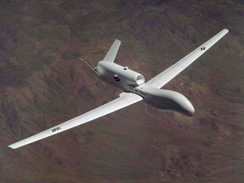
US Airforce/Tree Hugger
Figure 1: The Global Hawk has a body shape that helps with its aerodynamics.
Given the long history of flight, one would assume that UAV design would have drastically changed over the decades. While their outer layer composition varies, their overall shape has remained the same. The ostensible reason for this is that at the most basic level, UAVs still must fly. This yields very similar aerodynamic bodies throughout the industry, from Northrop Grumman’s Global Hawk UAV (see Fig. 1) to the General Atomic Aeronautical Systems’ RQ-1 Predator (see Fig. 2).
In their infancy, UAVs were constructed from lightweight woods such as balsa. They are now composed of space-age polymers such as “carbon-epoxy and Kevlar composite materials” [4].
Propulsion
Propellers continue to be the main mode of power for these unmanned vehicles. The RQ-1 Predator (see Fig. 2) has been powered by several different four-stroke engines during its twenty year history, but they all have driven a “1.5 m diameter, variable-pitch, pusher propeller” [4]. The propeller is in the shape of an airfoil. Airfoils are teardrop shapes that decrease the pressure of the air above its top surface.
US Airforce/Tree Hugger
Figure 2: The RQ-1 Raptor.
Guidance
From World War II until the late 1970s, UAVs relied exclusively on radio-controlled or television guidance. Modern UAVs, on the other hand, take advantage of another breakthrough in twentieth century technology, global positioning. The Global Positioning System (GPS) allows for specific points on a trajectory to be entered into a UAVs computer as longitude and latitude. The UAV will then pass through these waypoints and perform its mission at a pre-determined altitude.
With newly developed autonomous UAVs, image recognition path following has become an increasingly popular guidance system. This is accomplished by taking snapshots of the aircraft’s environment and comparing these images to those stored in the vehicle’s memory [5]. These new UAVs are designed around the US military’s central focus of real-time data acquisition and situational awareness.
Commercial Future
The military uses of UAVs have been explored extensively by governments around the world. The worldwide military demand for UAVs is expected to increase approximately 8% over the next four years [1]. With the declassification of some of the technology, the commercial sector has started looking into UAVs as well [6].
UAVs that monitor traffic patterns will soon be in service in major metropolitan areas. These robots would allow for city planners to adequately adjust light patterns and street widths to efficiently move commuters through cities. Coordinating the response of emergency vehicles to accidents is also in the future of civilian UAVs. Small UAVs, are being tested for this purpose.
The future of UAVs is not limited to municipal uses such as city planning. An expanded role in search and rescue efforts is inevitable for UAVs. In the aftermath of Hurricane Katrina, UAVs provided some of the first images of the extent of the damage [1]. Their ability to hover over an area for extended periods of time makes them ideal for these missions. It appears these weapons of war have a bright future helping people during peacetime.
References
-
- [1] L. Dickerson. “Demand for Unmanned Aerial Vehicles Increases Worldwide.” Aviation Week & Space Technology, pp. 111, Jan. 16, 2006.
- [2] L. Krock. “Timeline of UAVs”. Spies That Fly. http://www.pbs.org/wgbh/nova/spiesfly/uavs.html.
- [3] C.M. Hockmuth. “Tiny Hand-Launched UAV Available”. Aviation Weekly & Space Technology, pp. 538, Jan. 30, 2006.
- [4] M. Hewish. “Pilotless progress report – UAVs have made exceptional strides recently”. Jane’s International Defence Review. Internet: http://ww8.janes.com/Search/documentView.do?docId=/content1/janesdata/mags/idr, Oct.1, 2000.
- [5] R.C. Seals and E. Twum. “Computer Generated Images for Path Following for an Unmanned Vehicle.” The Institution of Electrical Engineers, pp.1-8, 1993.
- [6] M. DeGarmo and G.M. Nelson. “Prospective Unmanned Aerial Vehicle Operations in the Future National Airspace System.” American Institute of Aeronautics and Astronautics., pp. 1-8, September 20, 2004.